BW: 8 lbs on AMTRAK scale traveling to shuttle pickup point. May want to go lower…
A belated report (been busy), late summer I hiked the Oregon PCT sections from Ashland to a bit beyond Shelter Cove.
Description
Gear notes/summary
Photos
(no real map needed)
I’ve been on some of the same trail before (the part not on fire at the time) and in general, this summer was great as the big winter snows gave way to lush summer growth (unlike last time when the vegetation was dry and hot).
A lighter and much smaller pack on my back felt much better too. A little gear funk .. before starting the hike, I couldn’t get wide Altra’s or thin Darn Toughs, so started the hike wrestling with shoe/sock combos while having relief shipped to Crater Lake NP’s post office (most packages go to the Mazama store but merchant resupply stopped at the PO).
Getting dropped off near Callahan’s at I-5, I proceeded hiking the small ups and downs of small forests and small grasslands with Shasta coming into view. Felt a little hot but was excited to get going.
There were all sorts of PCT hikers (NOBO, SOBO, and this year “SNOBO”), plus various dayhikers, etc..
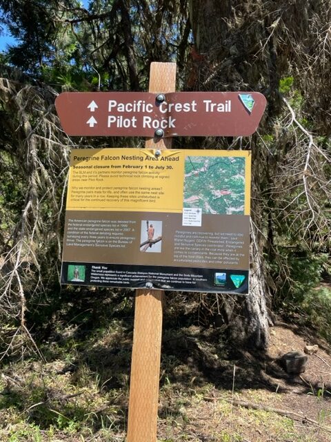
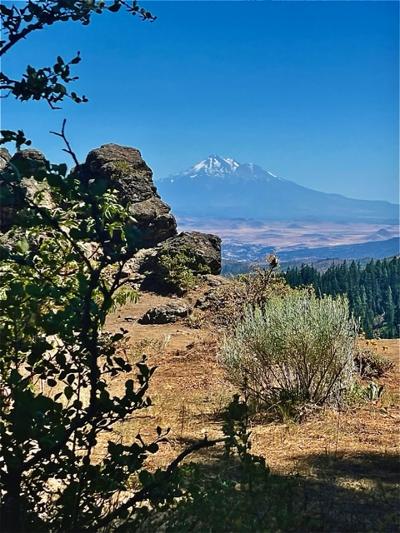
The afternoon started heating up even more as I passed “Pilot Rock” and the last good view of Shasta (some passing hikers told me 30 min later they encountered a rattler by the Pilot Rock overlook so I must have missed it) . Going for a bit more, started thinking about water and food. I went hiking further, eating and drinking water (mostly mixed with sugar-free lemonade mix) until reaching the next water source .. a meadow with a number of tents already up. I set up my tarp in a private spot and visited a bit with the other hikers .. no other tarp set ups. Sleep was uneventful.
Up the next morning, the hike seemed to go up a ridge .. so I kept going until reaching the road to Lake Hyatt (fishing lake with a restaurant and cabins). As I took a break a car stopped and a young couple asked if they had the right road (he was returning to thru hike and she was driving). They then offered me a ride to the restaurant which I accepted (figured an improvement over cheddar wrapped in tortilla). Much obliged.
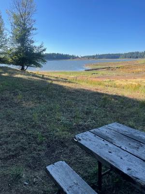
After eating, I walked back down the pavement for 2 miles back to the trailhead. The same couple drove by and said “hop in” .. however we only went a quarter mile before reaching the trailhead. I thanked them anyways, and left quickly so they could say their goodbyes. The afternoon grew a bit hot, so I would down a bit of water in the shade still acclimating. Surprised a few passing hikers (haha) in my mostly gray (except for stains) sun hoody but was simply sitting/drinking. Moving around south of Howard Prairie Lake the trail goes along a ridge, more little ups and downs skirting a Corp of Engineers (and now county) reservoir w/heavily forested RV park/boat launch. I detoured into the place, found it deserted, and had a snack/soup (recipe: ramen and boiling water) sitting at a picnic table and contemplated silence. The last time I was here the camp was packed and, feeling too early to set up camp, I started back to the trail. A few campsites were sorta tempting but sorta ”buggy”, so kept hiking more uphill. Big mistake as nighttime came pretty quick and I ended up setting up in the dark while talking to an unknown hiker in her tent. No dinner but the restaurant lunch and soup were enough. I slept ok but the slope made my rest a little tough to start. Ended ok but realized I had to get disciplined on breaks.
In the morning, I woke up, made my cold instant coffee, and drank recovering from my late evening. Packed, walked a little to filter the days water and away I went. There was a winter shelter with water pump on my route but I decided to pack a little more water. Good thing as I found out a bit later the Forest Service disabled the pump to preserve the water table (too much water being pumped). “Enlightened” by not much water, I made pretty good time to cross two highways and fill up at a rushing stream weirdly surrounded by dry vegetation. Right before that, there’s an intersecting multi-use trail that runs perpendicular to the PCT (“Fish Lake” and “Lake of the Woods” resorts) and some mountain bikers told me they’d just run into black bear. So I decided not to camp yet but keep going .. in this case up again (Mt McLoughlin). Reaching a large clearing, I quickly set up away from another tent (some section hikers just starting out) and ate. As the sun got low more hikers started to arrive. Sleep was ok but sounds (probably habituated deer) kept waking me up.
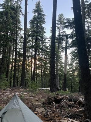
The next morning started a bit damp but got hot quickly. Stopping for water, I briefly spoke with other hikers coming and going, but once walking I was pretty much on my own. Despite the lakes surrounding me I got hot quickly as the trail track itself was dry. Pretty low on water now, the trail started up with some not-so-fun rocky sections on a south-facing slope. Downed trees presented an obstacle tripping me up once. Up and over the pass, then quickly down until I reached the first camp spot w/water. Plenty of tents were about with hiker settling in as I filtered the water. I decided to head downhill further to get closer to Crater Lake the next day, so quickly made my way down the trail racing the fading sunlight to get a good spot. I stopped right beside a creek and put up shelter for the night. Noticing some ants, I ignored them … until the middle of the night when I get a bite every hour or 2. Never again will my shelter not have a zipper! Got enough sleep but not particularly restful.
24 mile day according to notes .. shouldn’t have hit snooze on the alarm.
Waking up and breaking early, I stopped to fill up with water at the last camp before a dry stretch and luckily I didn’t camp there as it was a muddy mess.
I hiked down through an old burn that recovered nicely, mostly less sharp ups and downs. Pretty scorched uphill section leading towards the Crater Lk southern boundary.
I made it to Crater Lk, a shower, and dinner after coming in averaging 2 MPH. Having to stay a day to pick up some thinner socks (ordered and forwarded to the post office), I leisurely took in another day at Mazama. The site next to the hike/bike site had a party til midnight (groan). The next day, I ate breakfast as soon as possible then got to the Rim quickly to enjoy some coffee with a view and cell service. While up there, I met a southbound PCT hiker with a MLD Hell Pack. Should have asked what his gear list was in hindsight, but it was getting hot and I had to hike in the afternoon.
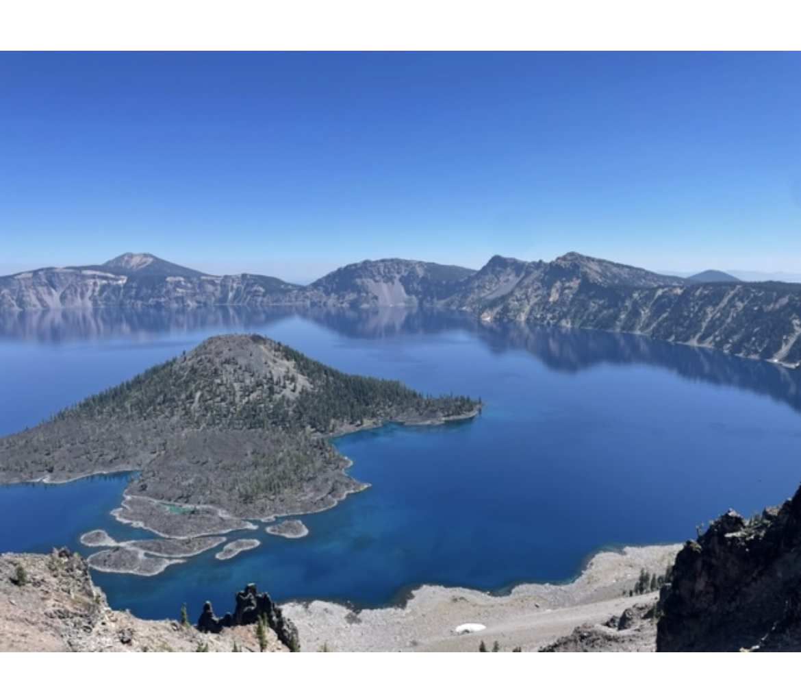
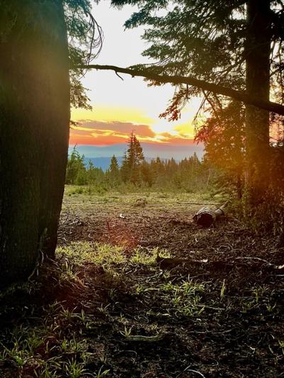
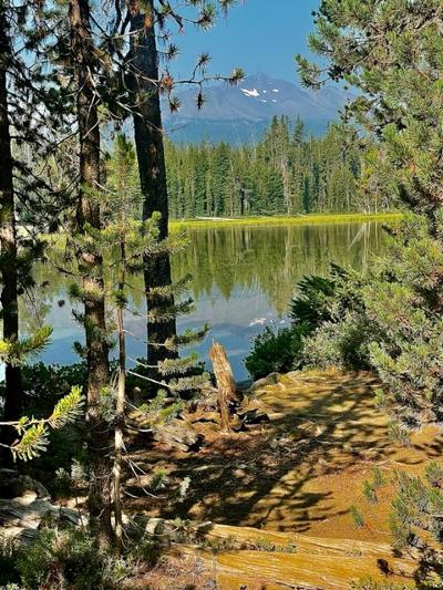
The rim was great (see cover photo) but hiking off of it, the trail quickly became a dead tree forest. Still peaceful enough so I could concentrate on miles and set up another camp. Some ants appeared but didn’t bug me (get it?). Plenty of campsites further north of the Crater Lk NP boundary, I found the next morning, so a bit of wasted time.
Climbing up towards the trail to Mt Thielsen, the air got a bit hazy. Not enough to stop me but it was an unwelcome presence. There was a respite while taking a break and water fill up at the Thielsen Creek meadow (thinking downhill air current), but besides worrying about condensation, I wanted to leave flat spots for the northbound trail crew. I kept climbing up and eventually committed to getting to the top of the pass. It did get hazier but more of an annoyance vs anything physical. I was feeling a bit lonely up there when upon reaching I reached the top of the pass, I saw 4 backpacking tents in the clearing. Seemed a bit breezy and the young hikers had puffy jackets (my packed octa was giving off unworthy vibes). I started heading down, but then decided to camp in a nearby treeline. Visiting a bit while setting up and eating I realized it wasn’t too bad up here and the breeze kept the haze moving. Sleep was deep.
Notes say 22 mile day and much was uphill. Probably could improve the pace a little, smaller breaks.
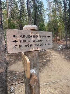
The next day started downhill with all of us passing each other until finally the younger hikers took off. There was then a few tough uphill parts, .. then I met a couple hiking with an infant going the other way at a water source. That gave me a little extra motivation to go that extra distance off the PCT at Windingo Pass, towards Crescent Lake using (via a little bit of the NB-60 dirt road) … the well marked Melotius/Whitehorse multi-use trail.
Kept up by bicycle riders, it was far smoother than the PCT track. Despite it being dinner time, I actually broke into a little run (the mosquitoes around some of the small nearby lakes “assisted”). Speaking with some SOBO hikers they’d been kept up by thunder and once in awhile I’d hear some towards Williamette Pass/higher PCT territory. Good thing too as I got to the deserted horse camp, night was already falling and I was sweating and quickly getting chilled. I briefly met the hikers from the previous night but quickly went to bed in the dark. Found out the horse camp was mostly deserted after the official host bailed for the season .. but room for the shelters!
27 mile day but ended the day at 9 w/no dinner. Maybe need to work out some marginal gear/time management issues.
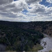
Next day, I spent a bit of time eating a good breakfast before leaving the horse camp and finding the alternate route via the “WhiteHorse Camp” trail north into Shelter Cove with a couple hikers (the Melotius part went towards the lake to Odell Lk and iirc was part of a pre-COVID attempt to make a bikepacking alternative to the PCT). I had to drink some water going up and the smoke was pretty thick going up into the almost swampy Diamond Pk Overlook Lk area. From there it was downhill towards Shelter Cove, meeting hikers and more trail crew before grabbing a burger at lunch. I took a shower and some beer as hikers I met came into the “hiker area”. Many decide to quit due to smoke and/or trail conditions arranging rides to mostly Bend. After relaxing in the AM, the next day I hiked a bit further past Williamette Pass and it had become noticeably smoky (fires from around Eugene and believe McKenzie Pass). I camped with no issue by a picturesque lake but the smoke became foggy with a worse experience likely towards Elk Lake/Bend (had service, so was able to check air quality maps). There were plenty campsites next to the “beach”, and most occupied by local picnicking. The next morning, after a swim (where someone left some “suds” in the water), I decided to head back to the pass w/another hiker who was leaving. I passed a bivy site with various street clothes along with a compound bow and arrow. Maybe time to turn it back to the hunter-bathers? I caught a hitch into Eugene ending my hike.
The season was great and having a smaller lighter pack helps. May bring earplugs as nighttime interruptions cause some tiredness the next day, but my next “cut” would have to be getting away from “mids” to save weight as I enjoy a hot dinner (i.e. maybe try a cat front entry tarp before trying cold soaking).
Gear specifics: The LiteAF 35 performed well especially with my daily mileage/ease of resupply .. and using a dimpled foam pad worked much better for summer back ventilation than I expected. The Deschutes Plus tarp worked great .. until needing a floor better than polycro. I’ll go back to a zipped inner (inner tent, bivy, etc..). The 550 is great for boiling water for packaged meals but cooking is a bit small (is it worth the oz?). A small fuel canister fits, but my Pocket Rocket stove barely bulges the lid .. though I tighten it all with the mesh bag. Everything else worked fine.
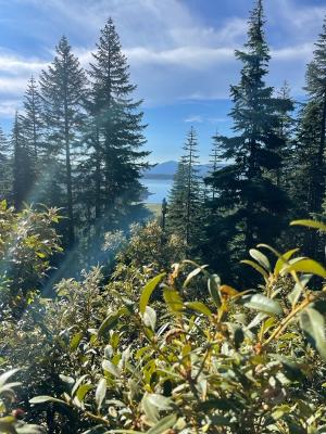
(Photo guide: signs on PCT and then Melitois trails, Pilot Rock and Shasta, Howard Prairie Lk picnic table area, my shelter top in the AM, some lake visible en route to Crater Lk, high point north of Mt Thielsen but south of Williamette Pass, Diamond Pk View Lk south of Williamette Pass and Shelter Cove)
Route: The PCT is well worn as is the Rim Trails and the Melotious-Whitehorse camp trails. Have to do a little dirt road walk on NB-60 to connect to the latter.


Home › Forums › TR: Southern Oregon/Crater Lk (PCT-Melotius trails)